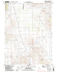
1980 Map of Fraser Flat
USGS Topo · Published 1984About this map
Warm Springs Valley serves as a central corridor for this arid Nevada basin, bounded by the Pah Rah Range to the east and the peaks of Dogskin Mountain to the northwest. The landscape in 1980 reflects a pattern of sparse cattle ranching and early prospecting, marked by various Corral sites and the Ruth Mine located on the slopes above Mullen Creek. The presence of several named water sources, such as Coyote Spring and Butler Spring, indicates the critical importance of water rights in this high-desert environment.
Find a feature on this map
27 named features on this map. Tap any name to fly to it.
Don’t see what you’re looking for? This feature index may not catch every label — zoom into the map to look around manually.
Map Details
Editions of this 1980 Fraser Flat Map
3 editions found
Other maps of this area

1891 · Reno
USGS Topo · 1:125,000

1893 · Reno
USGS Topo · 1:125,000

1950 · Reno
USGS Topo · 1:62,500

1951 · Reno
USGS Topo · 1:62,500

1957 · Sutcliffe
USGS Topo · 1:62,500

1957 · Dogskin Mountain
USGS Topo · 1:62,500

1957 · Spanish Springs Valley
USGS Topo · 1:62,500

1957 · Reno
USGS Topo · 1:250,000

1959 · Reno
USGS Topo · 1:250,000

1960 · Reno
USGS Topo · 1:250,000