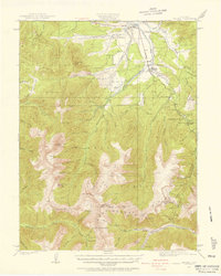
1924 Map of Fraser
USGS Topo · Published 1957About this map
Moffat Tunnel serves as a focal point in this high-altitude landscape, representing a critical engineering feat through the Continental Divide. The survey captures the mountain corridor during a period when the Denver and Salt Lake railroad dictated the local economy and settlement pattern. Towns and stops such as Tabernash, Fraser, and West Portal line the route, while smaller spurs like Wood Spur and Irving Spur suggest the area's industrial activity. High-mountain grazing and mining are evident through features like the Pole Creek School and the Urad Mine located near Jones Pass. This topography illustrates the rugged transition from the Fraser River valley to the alpine heights of Byers Peak and Mt Nystrom, documenting a working landscape where timber, mineral extraction, and transportation infrastructure converged in the early twentieth century.
Find a feature on this map
72 named features on this map. Tap any name to fly to it.
Don’t see what you’re looking for? This feature index may not catch every label — zoom into the map to look around manually.
Map Details
Editions of this 1924 Fraser Map
2 editions found
Other maps of this area

1903 · Georgetown
USGS Topo · 1:62,500

1905 · Central City
USGS Topo · 1:62,500

1905 · Georgetown
USGS Topo · 1:62,500

1910 · Central City
USGS Topo · 1:62,500

1912 · Central City
USGS Topo · 1:62,500

1915 · Longs Peak
USGS Topo · 1:125,000

1919 · Rocky Mountain National Park
USGS Topo · 1:125,000

1924 · Montezuma
USGS Topo · 1:62,500

1924 · Fraser
USGS Topo · 1:62,500

1926 · Fraser
USGS Topo · 1:62,500