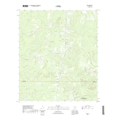
2019 Map of Fred
USGS Topo · Published 2019About this map
The settlement of Fred sits at the junction of several rural routes in Tyler County, serving as a primary point of human activity in this wooded pocket of East Texas. The landscape is heavily defined by its drainage patterns, with numerous named branches and creeks including Beech Cr, Franks Br, and Nixon Br winding through the terrain. A clear administrative boundary separates Tyler and Hardin Counties, crossing just north of the Big Thicket National Preserve. This protected area along the southern edge of the map encompasses low-lying features like Maple Slough and Mill Cr. The local infrastructure is marked by a dense network of county roads and the presence of the community Po, reflecting a landscape of timber-rich forests and scattered homesteads characteristic of the Piney Woods region.
Find a feature on this map
70 named features on this map. Tap any name to fly to it.
Don’t see what you’re looking for? This feature index may not catch every label — zoom into the map to look around manually.
Map Details
Editions of this 2019 Fred Map
This is the sole edition of this map. No revisions or reprints were ever made.
Other maps of this area

1954 · Beaumont
USGS Topo · 1:250,000

1955 · Silsbee
USGS Topo · 1:62,500

1955 · Kountze
USGS Topo · 1:62,500

1957 · Beaumont
USGS Topo · 1:250,000

1958 · Warren
USGS Topo · 1:62,500

1958 · Spurger
USGS Topo · 1:62,500

1984 · Beaumont
USGS Topo · 1:250,000

1984 · Potato Patch Lake
USGS Topo · 1:24,000
1984 · Spurger
USGS Topo · 1:24,000
1984 · Deserter Baygall
USGS Topo · 1:24,000