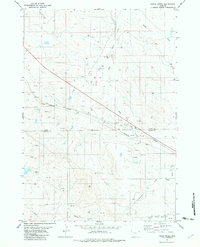
1982 Map of Freda Creek
USGS Topo · Published 1982About this map
The Kara Oil Field defines much of the industrial character of this landscape at the border of Crook Co Weston Co. By the early 1980s, the terrain was heavily marked by energy extraction, featuring numerous Oil Wells, Drill Holes, and a significant Pipeline that traverses the northern half of the sheet. This industrial activity is contrasted by a complex network of seasonal drainages, including Freda Creek, Wind Creek, and the Middle Fork Wind Creek in the south, which dissect the arid hills.
Find a feature on this map
16 named features on this map. Tap any name to fly to it.
Don’t see what you’re looking for? This feature index may not catch every label — zoom into the map to look around manually.
Map Details
Editions of this 1982 Freda Creek Map
This is the sole edition of this map. No revisions or reprints were ever made.
Other maps of this area

1918 · Moorcroft
USGS Topo · 1:125,000

1918 · Moorcroft
USGS Topo · 1:62,500

1954 · Gillette
USGS Topo · 1:250,000

1955 · Gillette
USGS Topo · 1:250,000

1957 · Nefsy Divide
USGS Topo · 1:62,500

1957 · Moorcroft
USGS Topo · 1:62,500

1957 · Upton
USGS Topo · 1:62,500

1958 · Gillette
USGS Topo · 1:250,000

1962 · Gillette
USGS Topo · 1:250,000

1979 · Sundance
USGS Topo · 1:100,000