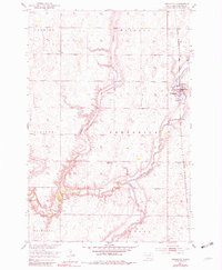
1953 Map of Frederick
USGS Topo · Published 1981About this map
The Frederick township and settlement center this mid-century survey of Brown County, where the plains are defined by the convergence of the Maple River and the Elm River. This map reveals a landscape structured by the Chicago Milwaukee St Paul and Pacific railroad and a grid of rural school districts. The presence of School No 1, School No 10, and the noted School No 2 (Abandoned) suggests the consolidation of local education as small homesteads transitioned into larger agricultural tracts. Land use is further illustrated by a Gravel Pit and the meandering path of Dry Branch, which cuts through the townships of Palmyra, Osceola, and Allison. The topography reflects the Missouri River Basin development era, capturing the transition from early settlement patterns to modern prairie land management.
Find a feature on this map
15 named features on this map. Tap any name to fly to it.
Don’t see what you’re looking for? This feature index may not catch every label — zoom into the map to look around manually.
Map Details
Editions of this 1953 Frederick Map
2 editions found
Other maps of this area

1894 · Ellendale
USGS Topo · 1:62,500

1894 · Columbia
USGS Topo · 1:62,500

1894 · Savo
USGS Topo · 1:62,500

1896 · Columbia
USGS Topo · 1:125,000

1899 · Ellendale
USGS Topo · 1:125,000

1952 · Westport
USGS Topo · 1:24,000

1952 · Richmond NE
USGS Topo · 1:24,000

1953 · Savo SW
USGS Topo · 1:24,000

1953 · Frederick
USGS Topo · 1:24,000

1953 · Ellendale South
USGS Topo · 1:24,000