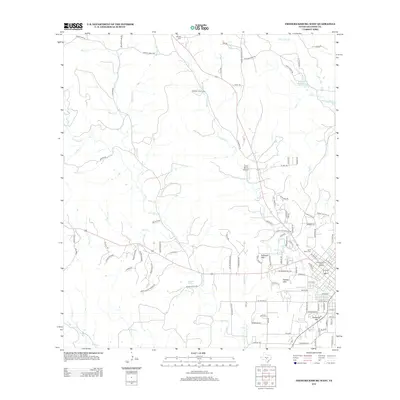
2012 Map of Fredericksburg West
USGS Topo · Published 2012About this map
The Fredericksburg Historic District serves as the focal point for this survey of the Texas Hill Country, documenting the western extent of this culturally significant community. The landscape is defined by its transition from the town grid to the surrounding uplands, featuring prominent rises such as Schneider Hill and the Schlaudt Hills. Numerous watercourses, including Barons Cr and Live Oak Cr, navigate the terrain, with historical crossings such as Barons Creek Xing noted on the map. For genealogists, the presence of the Saint Mary Cem and the more remote Schugh Cem offer specific locations for family research. The map also captures specialized land uses in the area, from the Carter Ranch Airport to reliable water sources like Guenther Spring, illustrating the blend of residential, agricultural, and aviation infrastructure in Gillespie County during the early 21st century.
Find a feature on this map
105 named features on this map. Tap any name to fly to it.
Don’t see what you’re looking for? This feature index may not catch every label — zoom into the map to look around manually.
Map Details
Editions of this 2012 Fredericksburg West Map
This is the sole edition of this map. No revisions or reprints were ever made.
Other maps of this area

1894 · Fredericksburg
USGS Topo · 1:125,000

1894 · Kerrville
USGS Topo · 1:125,000

1954 · Llano
USGS Topo · 1:250,000

1955 · Llano
USGS Topo · 1:250,000

1956 · Llano
USGS Topo · 1:250,000

1963 · Cain City
USGS Topo · 1:24,000

1964 · Oak Crest Park
USGS Topo · 1:24,000

1964 · Morris Ranch
USGS Topo · 1:24,000
1967 · Cherry Mountain
USGS Topo · 1:24,000

1967 · Fredericksburg East
USGS Topo · 1:24,000