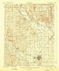
1942 Map of Fredonia
USGS Topo · Published 1942About this map
Fredonia serves as a major rail hub in this early 1940s landscape, where the Atchison Topeka and Santa Fe, Missouri Pacific, and St Louis San Francisco railroads converge. The terrain is defined by the winding courses of the Verdigris River and Fall River, which dictate the placement of early settlements and rural infrastructure. A dense network of one-room schoolhouses, including Needmore Sch, Forty Four Sch, and Triumph Sch, illustrates the distributed nature of the agrarian population before district consolidation. Notable landmarks like the County Farm and Leeper Bridge suggest a community with well-established social and civic structures. The presence of numerous family-named watercourses, such as Greathouse Creek and Ross Branch, provides valuable data for genealogists tracing ancestral land holdings near the Woodson and Wilson County line.
Find a feature on this map
74 named features on this map. Tap any name to fly to it.
Don’t see what you’re looking for? This feature index may not catch every label — zoom into the map to look around manually.
Map Details
Editions of this 1942 Fredonia Map
This is the sole edition of this map. No revisions or reprints were ever made.
Other maps of this area

1885 · Eureka
USGS Topo · 1:125,000

1885 · Sedan
USGS Topo · 1:125,000

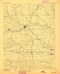
1886 · Fredonia
USGS Topo · 1:125,000

1886 · Independence
USGS Topo · 1:125,000

1888 · Eureka
USGS Topo · 1:125,000

1889 · Sedan
USGS Topo · 1:125,000

1894 · Fredonia
USGS Topo · 1:125,000

1894 · Independence
USGS Topo · 1:125,000
1894 · Eureka
USGS Topo · 1:125,000

1905 · Independence
USGS Topo · 1:125,000