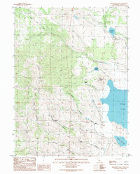
1989 Map of Fredonyer Peak
USGS Topo · Published 1989About this map
Fredonyer Peak and the high elevations of the Diamond Mountains dominate this northeastern California landscape as it was documented in the late 1980s. The region is defined by a significant water management network, where the seasonal waters of Horse Lake sit below the slopes of Horse Lake Mountain. This area reveals the historical footprint of high-altitude ranching and water storage, evidenced by Branham Reservoir, Fredonyer Reservoir, and the Craemer Reservoir. Numerous natural water sources, including Cottonwood Spring and Craemer Springs, feed into drainages like Shoals Creek and Middle Creek. Notable human-made features include the Woods Ranch Rock Walls and various other rock walls that delineate historical land use patterns and property boundaries across the high canyons.
Find a feature on this map
21 named features on this map. Tap any name to fly to it.
Don’t see what you’re looking for? This feature index may not catch every label — zoom into the map to look around manually.
Map Details
Editions of this 1989 Fredonyer Peak Map
This is the sole edition of this map. No revisions or reprints were ever made.
Other maps of this area

1886 · Honey Lake
USGS Topo · 1:250,000

1891 · Honey Lake
USGS Topo · 1:250,000

1893 · Honey Lake
USGS Topo · 1:250,000

1954 · Karlo
USGS Topo · 1:62,500

1954 · Grasshopper Valley
USGS Topo · 1:62,500

1954 · Ravendale
USGS Topo · 1:62,500

1954 · Fredonyer Peak
USGS Topo · 1:62,500

1955 · Westwood
USGS Topo · 1:250,000

1958 · Westwood
USGS Topo · 1:250,000

1959 · Westwood
USGS Topo · 1:250,000