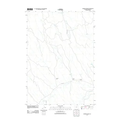
2012 Map of Fredrick Draw
USGS Topo · Published 2012About this map
Crazy Woman Cr winds through this section of Johnson County, defining a landscape shaped by intermittent water and high-plains drainage systems. The terrain is characterized by a series of prominent erosional features, including McMillan Draw, Antelope Draw, and the namesake Fredrick Draw. Water management in this semi-arid environment is evidenced by several scattered catchments, such as Rattlesnake Number 1 Reservoir to the north and Sony Reservoir and Bass Reservoir to the east. These man-made features highlight the ranching and livestock heritage of the region, providing vital resources where natural flowing water like Double Crossing Cr and Dry Cr may be seasonal. Transportation across these draws is facilitated by a network of local routes, most notably Double Crossing Rd and Tipperary Rd, which cut through the open country.
Find a feature on this map
13 named features on this map. Tap any name to fly to it.
Don’t see what you’re looking for? This feature index may not catch every label — zoom into the map to look around manually.
Map Details
Editions of this 2012 Fredrick Draw Map
This is the sole edition of this map. No revisions or reprints were ever made.
Other maps of this area

1900 · Fort McKinney
USGS Topo · 1:125,000

1903 · Fort McKinney
USGS Topo · 1:125,000

1909 · Sheridan
USGS Topo · 1:125,000

1911 · Sheridan
USGS Topo · 1:125,000

1955 · Sheridan
USGS Topo · 1:250,000

1958 · Sheridan
USGS Topo · 1:250,000

1962 · Sheridan
USGS Topo · 1:250,000

1970 · Buffalo NE
USGS Topo · 1:24,000
1970 · Buffalo SE
USGS Topo · 1:24,000
1970 · Ucross
USGS Topo · 1:24,000