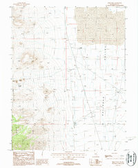
1987 Map of Freds Well
USGS Topo · Published 1988About this map
Railroad Valley meets the eastern slopes of the Reveille Range in this late-twentieth-century study of Nye County. The landscape is defined by its water sources, which dictated the survival and movement of people and livestock in this arid basin. Named points of interest such as Freds Well, Pyramid Well, and Last Stand Well appear alongside Pyramid Spring, indicating the vital infrastructure of high-desert ranching and travel.
Find a feature on this map
12 named features on this map. Tap any name to fly to it.
Don’t see what you’re looking for? This feature index may not catch every label — zoom into the map to look around manually.
Map Details
Editions of this 1987 Freds Well Map
This is the sole edition of this map. No revisions or reprints were ever made.
Other maps of this area

1908 · Kawich
USGS Topo · 1:250,000

1942 · Reveille Peak
USGS Topo · 1:125,000

1942 · Penoyer Valley
USGS Topo · 1:125,000

1952 · Reveille Peak
USGS Topo · 1:62,500

1954 · Caliente
USGS Topo · 1:250,000

1954 · Goldfield
USGS Topo · 1:250,000

1955 · Goldfield
USGS Topo · 1:250,000

1956 · Lund
USGS Topo · 1:250,000

1956 · Tonopah
USGS Topo · 1:250,000

1958 · Goldfield
USGS Topo · 1:250,000