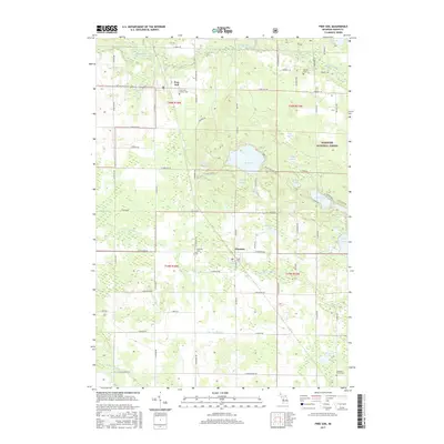
2017 Map of Free Soil
USGS Topo · Published 2017About this map
The Big Sable River flows through the northern reaches of this Mason County landscape, while the south is defined by the headwaters of the N Br Lincoln River and S Br Lincoln River. Centered on the village of Free Soil and the village of Fountain, the map reveals a countryside characterized by small kettle lakes and significant marshlands such as Frog Marsh. For those tracing local family history, several burial grounds are scattered across the townships, including Saint John Cantius Cem and the Meade Cem. Much of the eastern portion of the map is protected within the Manistee National Forest, where a cluster of water bodies like Gun Lake, Lake Meade, and Alma Lake sit among the timberland. The rectilinear grid of county roads, such as N Custer Rd and N Stephens Rd, connects these small communities to the surrounding woodlots and agricultural clearings.
Find a feature on this map
68 named features on this map. Tap any name to fly to it.
Don’t see what you’re looking for? This feature index may not catch every label — zoom into the map to look around manually.
Map Details
Editions of this 2017 Free Soil Map
This is the sole edition of this map. No revisions or reprints were ever made.
Other maps of this area

1931 · Custer NW
USGS Topo · 1:31,680

1931 · Custer NE
USGS Topo · 1:31,680

1931 · Manistee SE
USGS Topo · 1:31,680

1931 · Freesoil SW
USGS Topo · 1:31,680

1932 · Freesoil SE
USGS Topo · 1:31,680

1932 · Ludington NE
USGS Topo · 1:31,680

1954 · Milwaukee
USGS Topo · 1:250,000

1954 · Manitowoc
USGS Topo · 1:250,000

1957 · Freesoil
USGS Topo · 1:62,500

1958 · Manitowoc
USGS Topo · 1:250,000