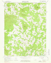
1965 Map of Free Union
USGS Topo · Published 1976About this map
Free Union serves as a central hub in this landscape where the foothills of the Blue Ridge meet the Piedmont. The map documents a period of transition, notably the development of the South Fork Rivanna River Reservoir, which would alter the local hydrology of the South Fork Rivanna River. The area is characterized by numerous small settlements and family-named landmarks like Boonesville, Blackwells, and Nortonsville. A deep religious and community history is evident through the placement of Good Shepherd Ch, Prize Hill Ch, and Wesley Chapel. The terrain is marked by significant rises including Buck Mountain, Green Mountain, and Pigeon Top Mtn, while the Peavine Trail suggests traditional routes through the various hollows such as Blackwells Hollow and Rockybar Hollow.
Find a feature on this map
41 named features on this map. Tap any name to fly to it.
Don’t see what you’re looking for? This feature index may not catch every label — zoom into the map to look around manually.
Map Details
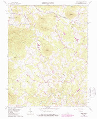
Editions of this 1965 Free Union Map
2 editions found
Other maps of this area

1892 · Gordonsville
USGS Topo · 1:125,000

1892 · Harrisonburg
USGS Topo · 1:125,000

1930 · Madison
USGS Topo · 1:48,000

1931 · University
USGS Topo · 1:62,500

1933 · Madison
USGS Topo · 1:62,500

1935 · Charlottesville
USGS Topo · 1:62,500

1935 · University
USGS Topo · 1:62,500

1937 · Elkton
USGS Topo · 1:62,500

1939 · Charlottesville
USGS Topo · 1:62,500

1949 · Charlottesville
USGS Topo · 1:250,000