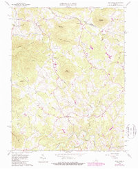
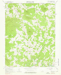
1965 Map of Free Union
USGS Topo · Published 1987About this map
Free Union and the surrounding Albemarle County countryside are defined by a network of rural crossroads and community churches in the mid-1960s. The landscape is structured by several prominent peaks, including Lick Mountain, Green Mountain, and Buck Mountain, which separate narrow valleys and hollows like Rockybar Hollow and Rich Hollow. Small clusters of development appear at Boonesville, Nortonsville, and Crossroads, often centered around local congregations such as Prize Hill Ch and Wesley Chapel. The southern edge of the map shows the transition to water-based infrastructure with the S Fk Rivanna River Res and the convergence of the Mechums River and Moormans River. These waterways, along with numerous creeks like Buck Mountain Creek and Elk Run, shaped the historical settlement patterns of this Piedmont region before modern suburban expansion reached these quiet hills.
Find a feature on this map
42 named features on this map. Tap any name to fly to it.
Don’t see what you’re looking for? This feature index may not catch every label — zoom into the map to look around manually.
Map Details
Editions of this 1965 Free Union Map
2 editions found
Other maps of this area

1892 · Gordonsville
USGS Topo · 1:125,000

1892 · Harrisonburg
USGS Topo · 1:125,000

1930 · Madison
USGS Topo · 1:48,000

1931 · University
USGS Topo · 1:62,500

1933 · Madison
USGS Topo · 1:62,500

1935 · Charlottesville
USGS Topo · 1:62,500

1935 · University
USGS Topo · 1:62,500

1937 · Elkton
USGS Topo · 1:62,500

1939 · Charlottesville
USGS Topo · 1:62,500

1949 · Charlottesville
USGS Topo · 1:250,000