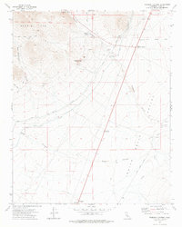
1972 Map of Freeman Junction
USGS Topo · Published 1975About this map
Freeman Junction and the tiny settlement of Armistead anchor this 1970s landscape where the high desert meets the southern Sierra Nevada foothills. The map documents critical water infrastructure through the Los Angeles Second Aqueduct, which winds across the arid terrain of the Indian Wells Valley. Traces of human activity are scattered throughout the canyons and washes, from the Black Hills Corral and Freeman Wash Well to several unnamed Mine and Prospects locations. To the west, the Scodie Mts rise sharply, dissected by drainages like Cow Heaven Canyon and Sage Canyon. The presence of Robbers Roost and Soldier Wells suggests a long history of travelers and outlaws navigating this demanding corridor, while the southern edge of the sheet identifies the Ruins at Harts Place, offering specific points of interest for those researching local history and desert heritage.
Find a feature on this map
23 named features on this map. Tap any name to fly to it.
Don’t see what you’re looking for? This feature index may not catch every label — zoom into the map to look around manually.
Map Details
Editions of this 1972 Freeman Junction Map
This is the sole edition of this map. No revisions or reprints were ever made.
Other maps of this area

1906 · Kernville
USGS Topo · 1:125,000

1908 · Kernville
USGS Topo · 1:125,000

1915 · Searles Lake
USGS Topo · 1:250,000

1915 · Mojave
USGS Topo · 1:125,000

1943 · Inyokern
USGS Topo · 1:62,500

1943 · Cross Mountain
USGS Topo · 1:62,500

1943 · Saltdale
USGS Topo · 1:62,500

1943 · Onyx
USGS Topo · 1:62,500

1947 · Trona
USGS Topo · 1:250,000

1948 · Trona
USGS Topo · 1:250,000