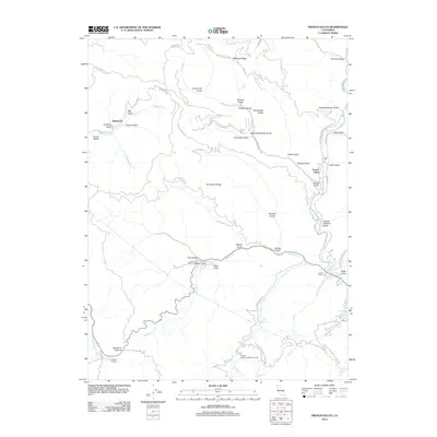
2012 Map of French Gulch
USGS Topo · Published 2012About this map
French Gulch and Deadwood anchor this 2012 survey of the Klamath Mountains, where the landscape is defined by a dense network of gulches and ridges that once fueled Northern California’s mining history. The steep drainage of Deadwood Cr and its southern fork contrast with the more prominent Clear Cr corridor, which traces the eastern edge of the map. Mining-era infrastructure remains visible through named features such as the Tom Green Mine Rd and the Lewiston Turnpike Rd, alongside a variety of industrial and labor landmarks like Sawpit Gulch, Slaughterhouse Gulch, and Yankee Gulch. To the south, the Whiskeytown Shasta-Trinity NRA encompasses Whiskeytown Falls and the Crystal Creek Conservation Camp, showing the area's transition toward conservation and forest management. Higher elevations are marked by Highland Ridge and Buckhorn Summit, while the small settlement of Shingle Shanty sits at the southwestern corner of the sheet.
Find a feature on this map
56 named features on this map. Tap any name to fly to it.
Don’t see what you’re looking for? This feature index may not catch every label — zoom into the map to look around manually.
Map Details
Editions of this 2012 French Gulch Map
This is the sole edition of this map. No revisions or reprints were ever made.
Other maps of this area

1890 · Red Bluff
USGS Topo · 1:250,000

1894 · Red Bluff
USGS Topo · 1:250,000

1913 · Weaverville
USGS Topo · 1:125,000

1944 · French Gulch
USGS Topo · 1:62,500

1948 · French Gulch
USGS Topo · 1:62,500

1950 · Minersville
USGS Topo · 1:62,500

1950 · Schell Mtn
USGS Topo · 1:62,500

1950 · Weaverville
USGS Topo · 1:62,500
1952 · Schell Mtn.
USGS Topo · 1:62,500

1952 · Weaverville
USGS Topo · 1:62,500