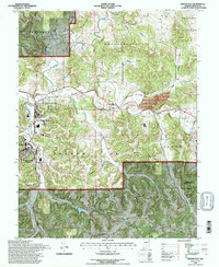
1993 Map of French Lick
USGS Topo · Published 1996About this map
French Lick and West Baden Springs anchor this detailed study of the southwestern Indiana karst topography, where the Lost River and French Lick Creek navigate a landscape of deep hollows. The presence of the Hoosier National Forest and the Paoli Experimental Forest highlights the region's managed woodlands, while numerous local landmarks like Ames Chapel and Moores Ridge Ch provide specific points of interest for genealogical research. A notable transportation insight is found in the various dismantled rail beds, marking a shift from the area's once-booming resort rail traffic to a more modern infrastructure. From the northern reaches of Orleans down through the French Lick township, the map documents a terrain marked by named features such as Stillhouse Hollow and Barnheisel Hollow, reflecting centuries of local settlement patterns and land use.
Find a feature on this map
43 named features on this map. Tap any name to fly to it.
Don’t see what you’re looking for? This feature index may not catch every label — zoom into the map to look around manually.
Map Details
Editions of this 1993 French Lick Map
This is the sole edition of this map. No revisions or reprints were ever made.
Other maps of this area

1948 · Huron
USGS Topo · 1:24,000

1949 · Georgia
USGS Topo · 1:24,000

1950 · Mitchell
USGS Topo · 1:24,000

1950 · Huron
USGS Topo · 1:24,000

1950 · Valeene
USGS Topo · 1:24,000

1951 · Hillham
USGS Topo · 1:24,000

1951 · French Lick
USGS Topo · 1:24,000

1951 · Georgia
USGS Topo · 1:24,000

1956 · Greenbrier
USGS Topo · 1:24,000

1956 · Vincennes
USGS Topo · 1:250,000