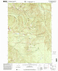
1997 Map of French Mountain
USGS Topo · Published 2001About this map
Willamette National Forest preserves a landscape of high-elevation peaks and protected wilderness in this late-1990s survey. Central to the map is the Three Sisters Wilderness, where the terrain is marked by significant topographical landmarks such as Olallie Mountain, French Mountain, and English Mountain. The drainage patterns of the Mc Kenzie Blue River basin are clearly visible, with Separation Creek and Horse Creek cutting deep into the forest.
Find a feature on this map
35 named features on this map. Tap any name to fly to it.
Don’t see what you’re looking for? This feature index may not catch every label — zoom into the map to look around manually.
Map Details
Editions of this 1997 French Mountain Map
This is the sole edition of this map. No revisions or reprints were ever made.
Other maps of this area

1925 · Waldo Lake
USGS Topo · 1:125,000

1929 · Three Sisters
USGS Topo · 1:125,000

1930 · Maiden Peak
USGS Topo · 1:125,000

1932 · Three Sisters
USGS Topo · 1:125,000

1934 · Maiden Peak
USGS Topo · 1:125,000

1934 · Mc Kenzie Bridge
USGS Topo · 1:96,000

1940 · Mc Kenzie Bridge
USGS Topo · 1:125,000

1953 · Salem
USGS Topo · 1:250,000

1954 · Salem
USGS Topo · 1:250,000

1955 · Chucksney Mtn
USGS Topo · 1:62,500