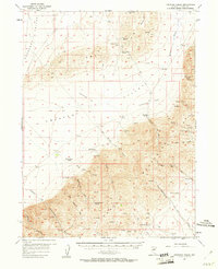
1957 Map of Frenchie Creek
USGS Topo · Published 1961About this map
Frenchie Ranch and several other family-named outposts anchor this mid-century survey of the high desert between the Cortez Mountains and Crescent Valley. The landscape is defined by its water sources, with isolated springs such as One Tank Spring and Hand-me-down Spring dictating the placement of early settlements and livestock operations. In the eastern portion of the quadrangle, the Modarelli Mines mark a site of industrial activity in the rugged foothills, while a network of jeep trails and older trails connects remote locations like Sod House and the Duff Ranch. The map captures the transition from traditional ranching to mid-century mineral exploration, particularly around Hot Spring and its nearby prospects. Geographers and local historians can trace the specific water-rights geography through numerous named features like Four Tanks Spring and Duff Spring.
Find a feature on this map
38 named features on this map. Tap any name to fly to it.
Don’t see what you’re looking for? This feature index may not catch every label — zoom into the map to look around manually.
Map Details
Editions of this 1957 Frenchie Creek Map
2 editions found
Other maps of this area

1937 · Mineral Hill
USGS Topo · 1:48,000

1938 · Cortez
USGS Topo · 1:48,000

1943 · Mineral Hill
USGS Topo · 1:62,500

1944 · Cortez
USGS Topo · 1:62,500

1949 · Crescent Valley
USGS Topo · 1:62,500

1950 · Crescent Valley
USGS Topo · 1:62,500

1952 · Pine Valley
USGS Topo · 1:62,500

1952 · Carlin
USGS Topo · 1:62,500

1955 · Winnemucca
USGS Topo · 1:250,000

1957 · Frenchie Creek
USGS Topo · 1:62,500