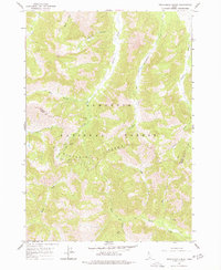
1964 Map of Frenchman Creek
USGS Topo · Published 1977About this map
Vienna (Site) sits at the heart of this high-elevation landscape, where the legacy of 19th-century silver mining is etched into the terrain of the Sawtooth Range. The 1964 field check reveals a network of industrial remnants, including ruins and specifically named operations like the Webfoot Mine, Solace Mine, and Vienna Mine. These sites are linked by high mountain drainages such as Smiley Creek and Vienna Creek, illustrating a period when resource extraction dictated the human geography of the Sawtooth National Forest. The map documents the boundary between Blaine County and Camas County, cutting through a landscape dominated by the headwaters of the Salmon River and Big Smoky Creek. Along with the primary mines, numerous Prospects scattered near Helen Creek and Mule Creek point to the intensive exploration that once defined this remote interior.
Find a feature on this map
25 named features on this map. Tap any name to fly to it.
Don’t see what you’re looking for? This feature index may not catch every label — zoom into the map to look around manually.
Map Details
Editions of this 1964 Frenchman Creek Map
3 editions found
Other maps of this area

1900 · Sawtooth
USGS Topo · 1:125,000

1955 · Hailey
USGS Topo · 1:250,000

1959 · Hailey
USGS Topo · 1:250,000

1962 · Hailey
USGS Topo · 1:250,000

1963 · Alturas Lake
USGS Topo · 1:24,000

1964 · Frenchman Creek
USGS Topo · 1:24,000
1964 · Snowyside Peak
USGS Topo · 1:24,000

1964 · Marshall Peak
USGS Topo · 1:24,000
1970 · Horton Peak
USGS Topo · 1:24,000

1970 · Paradise Peak
USGS Topo · 1:24,000