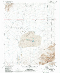
1986 Map of Frenchman Lake
USGS Topo · Published 1987About this map
The Nevada Test Site and the Nellis Air Force Range dominate this mid-1980s topograhic view, where government operations intersect with the stark geography of the Frenchman Flat. At the center of the sheet lies Frenchman Lake, a dry lake bed or playa containing a specific Blast Center, signifying the area's legacy of nuclear testing and scientific research. To the west, the Massachusetts Mountain Range rises above the basin, while the eastern boundary is marked by the Desert National Wildlife Range and the Desert Range. The map reveals a specialized landscape of security and infrastructure, featuring multiple Drill Holes, a Radio Tower, and a Water Tank Pumping Sta. Hydrological features like Cane Spring and the Winapi Wash provide a contrast to the high-security Restricted Access Area that cordons off much of the terrain.
Find a feature on this map
25 named features on this map. Tap any name to fly to it.
Don’t see what you’re looking for? This feature index may not catch every label — zoom into the map to look around manually.
Map Details
Editions of this 1986 Frenchman Lake Map
This is the sole edition of this map. No revisions or reprints were ever made.
Other maps of this area

1907 · Las Vegas
USGS Topo · 1:250,000

1908 · Furnace Creek
USGS Topo · 1:250,000

1908 · Las Vegas
USGS Topo · 1:250,000

1910 · Furnace Creek
USGS Topo · 1:250,000

1942 · Indian Spring
USGS Topo · 1:125,000

1942 · Skull Mountain
USGS Topo · 1:125,000

1948 · Death Valley
USGS Topo · 1:250,000

1952 · Specter Range
USGS Topo · 1:62,500

1952 · Mercury
USGS Topo · 1:62,500
1952 · Frenchman Lake
USGS Topo · 1:62,500