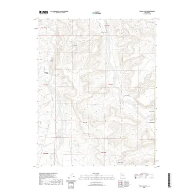
2020 Map of Fresno Canyon
USGS Topo · Published 2020About this map
Blanco Wash and the sweeping plateau of Blanco Mesa dominate this section of the San Juan Basin, where deeply incised drainage systems define the landscape. This 2020 record of San Juan County shows a terrain shaped by erosion and early energy exploration, evidenced by the remote Oil Test Spring located near Huerfanito Canyon. The map details a complex network of high-desert geography, including Hollis Pass and Jacquez Canyon, which provide essential passage through the mesa country. Modern infrastructure like Co RD 7007 and Carrizo Rd snakes through the topography, connecting the expansive Cañon Largo to smaller features such as Smith Canyon and Reed Canyon. The survey illustrates the intersection of natural landmarks and the systematic grid of public land surveys, maintaining the clear boundaries of the New Mexico interior.
Find a feature on this map
24 named features on this map. Tap any name to fly to it.
Don’t see what you’re looking for? This feature index may not catch every label — zoom into the map to look around manually.
Map Details
Editions of this 2020 Fresno Canyon Map
This is the sole edition of this map. No revisions or reprints were ever made.
Other maps of this area

1889 · Largo
USGS Topo · 1:250,000

1895 · Largo
USGS Topo · 1:250,000

1954 · Aztec
USGS Topo · 1:250,000

1958 · Aztec
USGS Topo · 1:250,000

1959 · Gould Pass
USGS Topo · 1:62,500

1959 · Nageezi
USGS Topo · 1:62,500

1960 · Bloomfield
USGS Topo · 1:62,500

1962 · Aztec
USGS Topo · 1:250,000

1965 · Aztec
USGS Topo · 1:250,000
1967 · Huerfano Trading Post
USGS Topo · 1:24,000