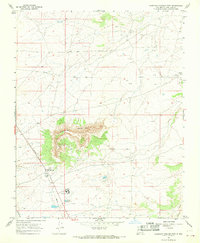
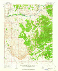
1967 Map of Huerfano Trading Post
USGS Topo · Published 1969About this map
Huerfano Mountain dominates the center of this high-desert landscape in San Juan County, rising sharply above the surrounding plateaus. In the late 1960s, this area served as a vital node for regional infrastructure and education, anchored by the Huerfano Trading Post and the nearby Berean Sch. The presence of the Dzilth-na-o-dith-hle Sch to the south reflects the essential role of institutional hubs in this dispersed community.
Find a feature on this map
13 named features on this map. Tap any name to fly to it.
Don’t see what you’re looking for? This feature index may not catch every label — zoom into the map to look around manually.
Map Details
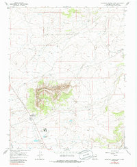
Editions of this 1967 Huerfano Trading Post Map
2 editions found
Other maps of this area

1889 · Largo
USGS Topo · 1:250,000

1895 · Largo
USGS Topo · 1:250,000

1954 · Aztec
USGS Topo · 1:250,000

1958 · Aztec
USGS Topo · 1:250,000
1959 · Gould Pass
USGS Topo · 1:62,500
1959 · Nageezi
USGS Topo · 1:62,500
1960 · Bloomfield
USGS Topo · 1:62,500

1962 · Aztec
USGS Topo · 1:250,000

1965 · Aztec
USGS Topo · 1:250,000
1966 · Huerfano Trading Post SW
USGS Topo · 1:24,000
Featured Places
- Eastern Navajo Agency, NM
- Dzilth-Na-O-Dith-Hle, NM
- Huerfano Trading Post, NM
- San Juan County, NM
- United States