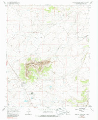
1967 Map of Huerfano Trading Post
USGS Topo · Published 1985About this map
Huerfano Mountain dominates this San Juan County landscape, providing a prominent natural landmark in a region defined by arid washes and industrial infrastructure. The 1967 survey reveals a sparse but functional network of desert activity centered around the Huerfano Trading Post, which sits near a Radio Tower and the Berean Sch. This era captures the expansion of energy resources across the high desert, evidenced by numerous Oil Wells and a major Pipeline cutting across the terrain.
Find a feature on this map
15 named features on this map. Tap any name to fly to it.
Don’t see what you’re looking for? This feature index may not catch every label — zoom into the map to look around manually.
Map Details
Editions of this 1967 Huerfano Trading Post Map
2 editions found
Other maps of this area

1889 · Largo
USGS Topo · 1:250,000

1895 · Largo
USGS Topo · 1:250,000

1954 · Aztec
USGS Topo · 1:250,000

1958 · Aztec
USGS Topo · 1:250,000

1959 · Gould Pass
USGS Topo · 1:62,500

1959 · Nageezi
USGS Topo · 1:62,500

1960 · Bloomfield
USGS Topo · 1:62,500

1962 · Aztec
USGS Topo · 1:250,000

1965 · Aztec
USGS Topo · 1:250,000
1966 · Huerfano Trading Post SW
USGS Topo · 1:24,000
Featured Places
- Eastern Navajo Agency, NM
- Dzilth-Na-O-Dith-Hle, NM
- Huerfano Trading Post, NM
- San Juan County, NM
- United States