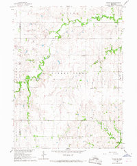
1966 Map of Friend SE
USGS Topo · Published 1967About this map
Turkey Creek meanders through the central Nebraska landscape, defining the rural character of this agricultural region in the mid-1960s. The map illustrates a grid of sections and townships across Saline and Fillmore counties, where small educational and community hubs like Standard Sch and Walnut Grove Sch served the surrounding farmsteads. These localized landmarks, along with the Turkey Creek Cem and Applegate Cem, provide essential anchor points for researchers tracing family history in the Turkey Creek and Atlanta townships. Evidence of local industry is visible through numerous Gravel Pits and a Sandpit situated near the watercourses, while the southern reaches are drained by the North Fork Swan Creek.
Find a feature on this map
19 named features on this map. Tap any name to fly to it.
Don’t see what you’re looking for? This feature index may not catch every label — zoom into the map to look around manually.
Map Details
Editions of this 1966 Friend SE Map
This is the sole edition of this map. No revisions or reprints were ever made.
Other maps of this area

1935 · Dorchester
USGS Topo · 1:48,000

1940 · Dorchester
USGS Topo · 1:62,500

1955 · Lincoln
USGS Topo · 1:250,000

1957 · Lincoln
USGS Topo · 1:250,000

1958 · Lincoln
USGS Topo · 1:250,000

1961 · Tobias
USGS Topo · 1:24,000
1961 · Ohiowa
USGS Topo · 1:24,000

1961 · Western
USGS Topo · 1:24,000
1964 · Dorchester NW
USGS Topo · 1:24,000
1966 · Dorchester SW
USGS Topo · 1:24,000