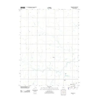
2011 Map of Friend SW
USGS Topo · Published 2011About this map
Milligan anchors the southeastern corner of this Nebraska landscape, where the town's local civic life is marked by the Milligan Post Office. This agricultural region in Fillmore County is defined by a rigorous grid of section-line roads, such as Road 19 and Road M, which partition the prairie into large-scale farming tracts. Water management and recreation are central to the geography here, evidenced by the Cedar View Recreation Reservoir and the Kubicek Dam situated along a tributary.
Find a feature on this map
21 named features on this map. Tap any name to fly to it.
Don’t see what you’re looking for? This feature index may not catch every label — zoom into the map to look around manually.
Map Details
Editions of this 2011 Friend SW Map
This is the sole edition of this map. No revisions or reprints were ever made.
Other maps of this area

1898 · York
USGS Topo · 1:125,000

1898 · Hebron
USGS Topo · 1:125,000

1899 · York
USGS Topo · 1:125,000

1955 · Lincoln
USGS Topo · 1:250,000

1957 · Lincoln
USGS Topo · 1:250,000

1958 · Lincoln
USGS Topo · 1:250,000

1961 · Tobias
USGS Topo · 1:24,000
1961 · Ohiowa
USGS Topo · 1:24,000
1966 · Friend
USGS Topo · 1:24,000
1966 · Friend SE
USGS Topo · 1:24,000