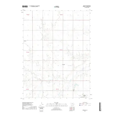
2017 Map of Friend SW
USGS Topo · Published 2017About this map
Milligan anchors the southeastern corner of this Fillmore County landscape, where the grid of rural section lines meets the drainage system of Turkey Creek. The area is defined by its agricultural heritage and communal structures, notably the Townhall situated centrally near RD K and RD 22. This 2017 survey reflects the persistent settlement patterns of the Nebraska plains, from the small community at Burress in the west to the local water management seen at the Cedar View Recreation Reservoir. Genealogical interest is found at the Bohemian Brethren Cem, located south of the reservoir near the S Fork Turkey Cr. The terrain is characterized by the gentle dissection of the uplands by Turkey Creek and its various branches, including the Turkey Cr fork, which meanders through the township sections.
Find a feature on this map
29 named features on this map. Tap any name to fly to it.
Don’t see what you’re looking for? This feature index may not catch every label — zoom into the map to look around manually.
Map Details
Editions of this 2017 Friend SW Map
This is the sole edition of this map. No revisions or reprints were ever made.
Other maps of this area

1898 · York
USGS Topo · 1:125,000

1898 · Hebron
USGS Topo · 1:125,000

1899 · York
USGS Topo · 1:125,000

1955 · Lincoln
USGS Topo · 1:250,000

1957 · Lincoln
USGS Topo · 1:250,000

1958 · Lincoln
USGS Topo · 1:250,000

1961 · Tobias
USGS Topo · 1:24,000
1961 · Ohiowa
USGS Topo · 1:24,000
1966 · Friend
USGS Topo · 1:24,000
1966 · Friend SE
USGS Topo · 1:24,000