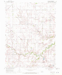
1969 Map of Friend SW
USGS Topo · Published 1971About this map
Agricultural townships in Fillmore County, including Liberty and Glengary, define this prairie landscape as it appeared in the late 1960s. The village of Milligan serves as a local hub in the southeast corner, distinguished by the Bohemian Brethren church and its proximity to the Burlington Northern railroad line. Further north, the tiny settlement of Burress sits along the Chicago and North Western tracks, illustrating the importance of rail corridors to the regional grain economy. The terrain is bisected by the meandering course of Turkey Creek and its South Fork, which create localized relief against the otherwise surveyed grid of field lines and section roads. Other local landmarks include a solitary Grave and a rural Townhall, marking quiet points of community history within the township boundaries of Exeter, Madison, and Chelsea.
Find a feature on this map
16 named features on this map. Tap any name to fly to it.
Don’t see what you’re looking for? This feature index may not catch every label — zoom into the map to look around manually.
Map Details
Editions of this 1969 Friend SW Map
This is the sole edition of this map. No revisions or reprints were ever made.
Other maps of this area

1898 · York
USGS Topo · 1:125,000

1898 · Hebron
USGS Topo · 1:125,000

1899 · York
USGS Topo · 1:125,000

1955 · Lincoln
USGS Topo · 1:250,000

1957 · Lincoln
USGS Topo · 1:250,000

1958 · Lincoln
USGS Topo · 1:250,000

1961 · Tobias
USGS Topo · 1:24,000
1961 · Ohiowa
USGS Topo · 1:24,000
1966 · Friend
USGS Topo · 1:24,000
1966 · Friend SE
USGS Topo · 1:24,000