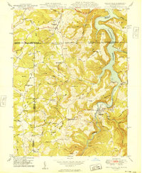
1949 Map of Friendsville
USGS Topo · Published 1949About this map
The Mason And Dixon Line cuts across this 1940s landscape, marking the historic boundary between Maryland and Pennsylvania. This survey, conducted just after the mid-century, captures the Youghiogheny Reservoir filling the valley north of Friendsville, a major geographic change that altered the local landscape around Selbysport and the old Great Crossing Ch. To the west, the National Pike traverses the northern edge near Markleysburg, while a network of rural schools and churches like Webb Chapel, Blooming Rose Ch, and the South Avenue Sch serve the scattered farming communities.
Find a feature on this map
68 named features on this map. Tap any name to fly to it.
Don’t see what you’re looking for? This feature index may not catch every label — zoom into the map to look around manually.
Map Details
Editions of this 1949 Friendsville Map
This is the sole edition of this map. No revisions or reprints were ever made.
Other maps of this area

1900 · Accident
USGS Topo · 1:62,500

1900 · Uniontown
USGS Topo · 1:62,500

1904 · Bruceton
USGS Topo · 1:62,500

1922 · Confluence
USGS Topo · 1:62,500

1926 · Bruceton
USGS Topo · 1:62,500

1931 · Uniontown
USGS Topo · 1:62,500

1931 · Confluence
USGS Topo · 1:62,500

1931 · Bruceton Mills
USGS Topo · 1:62,500

1933 · Confluence
USGS Topo · 1:62,500

1933 · Bruceton
USGS Topo · 1:62,500