
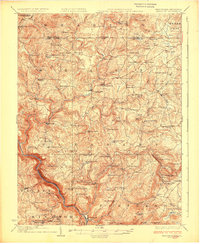
1926 Map of Bruceton
USGS Topo · Published 1926About this map
The Cheat River carves a deep valley through the southwestern corner of this West Virginia and Pennsylvania borderland, providing a dramatic backdrop for the rural communities of the 1920s. Centered around Bruceton Mills and Brandonville, the landscape is defined by its agrarian and early industrial character, where numerous grist and sawmills once operated. A high density of country schools, such as the Shafer School and Deep Hollow School, along with spiritual centers like the Old Brick Church and St Peters Church, reflect a closely-knit network of small mountain settlements. This era shows the region just before modern infrastructure reshaped these hollows, with the Baltimore and Ohio Railroad and the Pipe Line marking the ingress of industrial transport. Traces of early extraction are visible at the Gaflisch Mine, while the many cemeteries, including Pleasant Grove Cem, provide vital touchpoints for local genealogy.
Find a feature on this map
109 named features on this map. Tap any name to fly to it.
Don’t see what you’re looking for? This feature index may not catch every label — zoom into the map to look around manually.
Map Details
Editions of this 1926 Bruceton Map
2 editions found
Other maps of this area

1886 · St. George
USGS Topo · 1:125,000

1891 · St. George
USGS Topo · 1:125,000

1895 · Piedmont
USGS Topo · 1:125,000

1899 · Oakland
USGS Topo · 1:62,500

1900 · Accident
USGS Topo · 1:62,500

1900 · Oakland
USGS Topo · 1:62,500

1900 · Uniontown
USGS Topo · 1:62,500

1900 · Masontown
USGS Topo · 1:62,500

1902 · Morgantown
USGS Topo · 1:62,500

1903 · Masontown
USGS Topo · 1:62,500