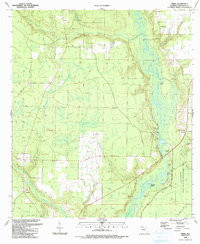
1990 Map of Frink
USGS Topo · Published 1990About this map
The Chipola River flows through this panhandle landscape, creating a network of sloughs and swamps that define the local geography. Near the river's edge, Scotts Ferry and Abe Springs represent long-standing riverfront points of interest. The map reveals a pattern of rural life organized around modest settlements like Frink and Kinard, where community identity centers on local institutions such as Williams Memorial Ch and Cypress Cr Ch. The topography transition toward the Dead Lakes in the south provides insight into the hydrologic character of the region before further modern development. Genealogists will find value in the precise locations of family-named landmarks like McClellan Cem and the various bluffs and landings, including Frozen Bluff and Blazed Pine Landing, which hint at a time when river transport was vital to Calhoun County commerce.
Find a feature on this map
35 named features on this map. Tap any name to fly to it.
Don’t see what you’re looking for? This feature index may not catch every label — zoom into the map to look around manually.
Map Details
Editions of this 1990 Frink Map
This is the sole edition of this map. No revisions or reprints were ever made.
Other maps of this area

1944 · Clarksville
USGS Topo · 1:31,680

1945 · Dead Lake
USGS Topo · 1:31,680

1945 · Juniper Creek
USGS Topo · 1:31,680

1945 · Blountstown
USGS Topo · 1:31,680

1945 · Clarksville
USGS Topo · 1:31,680

1945 · Broad Branch
USGS Topo · 1:31,680

1945 · Estiffanulga
USGS Topo · 1:31,680

1945 · Orange
USGS Topo · 1:31,680

1945 · Frink
USGS Topo · 1:31,680

1945 · Tenmile Swamp
USGS Topo · 1:31,680