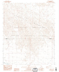
1988 Map of Frink NE
USGS Topo · Published 1988About this map
The Chocolate Mountains dominate this 1980s landscape, their steep ridgelines and complex topography serving as a significant geographical barrier across the Riverside and Imperial county line. Large portions of the terrain are designated as an Aerial Gunnery Range, reflecting the area's mid-century role in military training and desert maneuvers. Human infrastructure is concentrated in the southwest corner, where the Coachella Canal flows past a siphon and a protective Dike. This irrigation artery contrasts sharply with the arid mountain slopes and the utility of the nearby Rock Quarry. The presence of 4wd trails provides the only access into the back-country of the range, highlighting the isolated and controlled nature of this desert environment during the late 20th century.
Find a feature on this map
10 named features on this map. Tap any name to fly to it.
Don’t see what you’re looking for? This feature index may not catch every label — zoom into the map to look around manually.
Map Details
Editions of this 1988 Frink NE Map
3 editions found
Other maps of this area

1940 · Frink
USGS Topo · 1:62,500

1940 · Iris Pass
USGS Topo · 1:62,500

1940 · Canyon Spring
USGS Topo · 1:62,500

1943 · Canyon Spring
USGS Topo · 1:62,500

1944 · Chuckwalla Mountains
USGS Topo · 1:62,500

1944 · Frink
USGS Topo · 1:62,500

1945 · Iris Pass
USGS Topo · 1:62,500

1954 · Salton Sea
USGS Topo · 1:250,000

1955 · Salton Sea
USGS Topo · 1:250,000

1956 · Frink NW
USGS Topo · 1:24,000