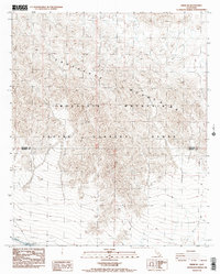
1988 Map of Frink NE
USGS Topo · Published 1988About this map
The Chocolate Mountains dominate this 1988 provisional survey, defining a landscape largely designated as an Aerial Gunnery Range. Situated along the boundary of Riverside Co and Imperial Co, the map documents the intersection of military airspace and essential water infrastructure. In the lower-left corner, the engineered path of the Coachella Canal cuts across the arid terrain, supported by a Siphon and a prominent Dike to manage flow through the desert. Human industry is further evidenced by a Rock Quarry, indicating localized extraction efforts amidst the high-relief topography. This map captures a specific late-century moment when remote desert reaches were utilized for both tactical training and large-scale water transport, providing a clear record of the area's specialized land use and infrastructure prior to modern developments.
Find a feature on this map
8 named features on this map. Tap any name to fly to it.
Don’t see what you’re looking for? This feature index may not catch every label — zoom into the map to look around manually.
Map Details
Editions of this 1988 Frink NE Map
3 editions found
Other maps of this area

1940 · Frink
USGS Topo · 1:62,500

1940 · Iris Pass
USGS Topo · 1:62,500

1940 · Canyon Spring
USGS Topo · 1:62,500

1943 · Canyon Spring
USGS Topo · 1:62,500

1944 · Chuckwalla Mountains
USGS Topo · 1:62,500

1944 · Frink
USGS Topo · 1:62,500

1945 · Iris Pass
USGS Topo · 1:62,500

1954 · Salton Sea
USGS Topo · 1:250,000

1955 · Salton Sea
USGS Topo · 1:250,000

1956 · Frink NW
USGS Topo · 1:24,000