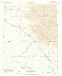
1956 Map of Frink NW
USGS Topo · Published 1965About this map
The Chocolate Mountains dominate the eastern landscape of this desert survey, where industrial and military utility intersect with unique desert developments. The northern sector is defined by the Chocolate Mountain Aerial Gunnery Range and a dedicated Mining Railroad, while the lower elevations reveal the vital infrastructure of the Coachella Canal. This waterway, marked by a series of numbered structures like Siphon 21 and Siphon 18, skirts the Naval Reservation Boundary. Perhaps most striking is the presence of the Hot Mineral Spa and a Tropical Fish Farm near the center of the sheet, indicating specialized aquaculture and recreation in an otherwise arid environment. Evidence of local industry is found at several Rock Quarry sites and a Gravel Pit near the Southern Pacific tracks, illustrating how natural resources and transportation networks were managed during the mid-1950s.
Find a feature on this map
22 named features on this map. Tap any name to fly to it.
Don’t see what you’re looking for? This feature index may not catch every label — zoom into the map to look around manually.
Map Details
Editions of this 1956 Frink NW Map
3 editions found

Other maps of this area

1940 · Frink
USGS Topo · 1:62,500

1940 · Cottonwood Spring
USGS Topo · 1:62,500

1940 · Canyon Spring
USGS Topo · 1:62,500

1940 · Durmid
USGS Topo · 1:62,500

1943 · Canyon Spring
USGS Topo · 1:62,500

1944 · Cottonwood Spring
USGS Topo · 1:62,500

1944 · Durmid
USGS Topo · 1:62,500

1944 · Frink
USGS Topo · 1:62,500

1954 · Salton Sea
USGS Topo · 1:250,000

1955 · Salton Sea
USGS Topo · 1:250,000