
1966 Map of Friona
USGS Topo · Published 1968About this map
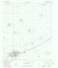
Friona anchors this High Plains landscape during the mid-1960s, serving as a hub of agriculture and transit along the Atchison Topeka and Santa Fe railroad line. The town's layout reflects a self-contained community, featuring its own High Sch, a Country Club, and a Drive-in Theater on the western edge. Notable for its infrastructure, the area includes the Benger Airpark and Reeve Field, alongside multiple radio installations like Radio Tower (KNNN).
Find a feature on this map
22 named features on this map. Tap any name to fly to it.
Don’t see what you’re looking for? This feature index may not catch every label — zoom into the map to look around manually.
Map Details
Editions of this 1966 Friona Map
2 editions found
Other maps of this area

1954 · Clovis
USGS Topo · 1:250,000

1958 · Clovis
USGS Topo · 1:250,000

1965 · Tam Anne
USGS Topo · 1:24,000

1965 · Parmerton
USGS Topo · 1:24,000

1965 · Hub
USGS Topo · 1:24,000

1965 · Twin Lakes
USGS Topo · 1:24,000

1966 · Summerfield
USGS Topo · 1:24,000

1970 · Chalk Hill
USGS Topo · 1:24,000

1971 · Westway
USGS Topo · 1:24,000

1971 · Bootleg
USGS Topo · 1:24,000