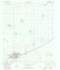
1966 Map of Friona
USGS Topo · Published 1981About this map
The High Plains landscape of Friona is dominated by the strategic intersection of the Atchison Topeka and Santa Fe railroad and the natural drainage of Frio Draw. This 1960s-era survey reveals a community balancing its agricultural roots with mid-century modernizations, featuring a Drive-in Theater, a Country Club, and the Rodeo Ground. The presence of Benger Airpark and multiple radio towers, including Radio Tower (KNNN), underscores the town's role as a regional hub for communication and transit in Parmer County.
Find a feature on this map
18 named features on this map. Tap any name to fly to it.
Don’t see what you’re looking for? This feature index may not catch every label — zoom into the map to look around manually.
Map Details
Editions of this 1966 Friona Map
2 editions found
Other maps of this area

1954 · Clovis
USGS Topo · 1:250,000

1958 · Clovis
USGS Topo · 1:250,000

1965 · Tam Anne
USGS Topo · 1:24,000

1965 · Parmerton
USGS Topo · 1:24,000

1965 · Hub
USGS Topo · 1:24,000

1965 · Twin Lakes
USGS Topo · 1:24,000

1966 · Friona
USGS Topo · 1:24,000

1966 · Summerfield
USGS Topo · 1:24,000

1970 · Chalk Hill
USGS Topo · 1:24,000

1971 · Westway
USGS Topo · 1:24,000