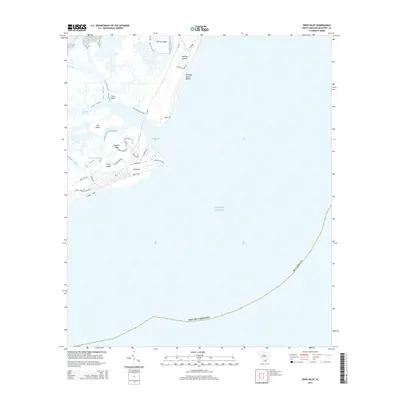
2014 Map of Fripp Inlet
USGS Topo · Published 2014About this map
Fripp Island and Hunting Island define this coastal landscape where the Atlantic Ocean meets a complex network of barrier islands and tidal creeks. This 2014 survey captures the residential development and natural preservation of the South Carolina Lowcountry, showing the dense residential street networks of Fripp Island contrasted with the open reaches of Hunting Island Beach. Navigation and access points are clearly marked, such as the Russ Point Boat Lndg and the connection provided by SC-406. The map provides a detailed view of the shifting waterways between the islands, including Fripp Inlet, Old House Creek, and the Harbor River, documenting the intricate relationship between the land and the sea in Beaufort County. Local neighborhoods like Fiddlers Ridge are situated among these marshy estuaries and maritime forests.
Find a feature on this map
35 named features on this map. Tap any name to fly to it.
Don’t see what you’re looking for? This feature index may not catch every label — zoom into the map to look around manually.
Map Details
Editions of this 2014 Fripp Inlet Map
This is the sole edition of this map. No revisions or reprints were ever made.
Other maps of this area

1920 · St. Helena Sound
USGS Topo · 1:62,500

1920 · Hilton Head
USGS Topo · 1:62,500

1944 · Fort Fremont
USGS Topo · 1:62,500

1945 · Hilton Head
USGS Topo · 1:62,500

1947 · Savannah
USGS Topo · 1:250,000

1948 · St. Helena Sound
USGS Topo · 1:62,500

1948 · Savannah
USGS Topo · 1:250,000

1956 · Frogmore
USGS Topo · 1:24,000
1956 · Edisto Beach
USGS Topo · 1:24,000
1956 · St. Helena Sound
USGS Topo · 1:24,000