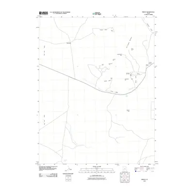
2010 Map of Frisco
USGS Topo · Published 2010About this map
San Francisco Mountains define the high ground of this mining district in western Utah, where a legacy of silver and copper extraction remains etched into the landscape. Significant operations concentrate around Frisco and Newhouse, including the renowned Horn Silver Mine and the Cactus Mine to the northwest. These sites, along with the Old King David Mine and Lulu Mine, reflect an era of intense industrial activity that once drove the local economy.
Find a feature on this map
25 named features on this map. Tap any name to fly to it.
Don’t see what you’re looking for? This feature index may not catch every label — zoom into the map to look around manually.
Map Details
Editions of this 2010 Frisco Map
This is the sole edition of this map. No revisions or reprints were ever made.
Other maps of this area

1953 · Richfield
USGS Topo · 1:250,000

1958 · Richfield
USGS Topo · 1:250,000

1958 · Milford
USGS Topo · 1:62,500

1959 · Frisco
USGS Topo · 1:62,500

1960 · Frisco Peak
USGS Topo · 1:62,500

1960 · Beaver Lake Mts.
USGS Topo · 1:62,500

1980 · Wah Wah Mts. South
USGS Topo · 1:100,000

1980 · Wah Wah Mts. North
USGS Topo · 1:100,000
1989 · High Rock
USGS Topo · 1:24,000
1989 · Frisco Peak
USGS Topo · 1:24,000