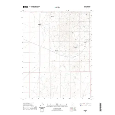
2020 Map of Frisco
USGS Topo · Published 2020About this map
Frisco and Newhouse sit at the center of this high-desert landscape in Beaver County, representing the remnants of once-thriving mining activity. The map follows the stark topography from Grampian Hill to the heights of Indian Grave Peak and Squaw Peak, where the terrain is carved by numerous drainages such as Copper Gulch and Loeber Gulch. This 2020 survey documents the modern footprint of these historic mining districts, preserving the location of the Frisco Cem and the vital water sources that sustained early settlement, including Squaw Spring and Antelope Springs. The layout of the land shows a clear relationship between the steep slopes of Frisco Summit and the alluvial plains of Frisco Wash, illustrating the harsh environment that defined the local economy and survival in this part of the San Francisco Mountains.
Find a feature on this map
15 named features on this map. Tap any name to fly to it.
Don’t see what you’re looking for? This feature index may not catch every label — zoom into the map to look around manually.
Map Details
Editions of this 2020 Frisco Map
This is the sole edition of this map. No revisions or reprints were ever made.
Other maps of this area

1953 · Richfield
USGS Topo · 1:250,000

1958 · Richfield
USGS Topo · 1:250,000

1958 · Milford
USGS Topo · 1:62,500

1959 · Frisco
USGS Topo · 1:62,500

1960 · Frisco Peak
USGS Topo · 1:62,500

1960 · Beaver Lake Mts.
USGS Topo · 1:62,500

1980 · Wah Wah Mts. South
USGS Topo · 1:100,000

1980 · Wah Wah Mts. North
USGS Topo · 1:100,000
1989 · High Rock
USGS Topo · 1:24,000
1989 · Frisco Peak
USGS Topo · 1:24,000