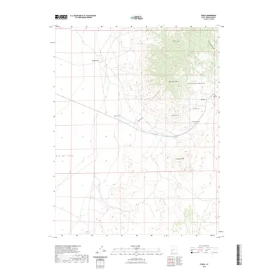
2023 Map of Frisco
USGS Topo · Published 2023About this map
Frisco and Newhouse sit at the desert edge in Beaver County, marking the site of once-thriving mining operations in the San Francisco Mountains. This 2023 survey documents the topography of a landscape defined by its mineral history, with the peaks and gulches that once supported silver and copper extraction. Modern contours trace the steep rise of Grampian Hill and Indian Grave Peak, while the Frisco Cem remains a quiet marker of the community that once gathered here. To the west, the land levels into the wide Wah Wah Valley, a sharp contrast to the drainage networks of Carbonate Gulch and Loeber Gulch that cut through the highlands. Small water sources like Frisco Spring and Antelope Springs hint at the precious resources that made settlement possible in this arid environment.
Find a feature on this map
17 named features on this map. Tap any name to fly to it.
Don’t see what you’re looking for? This feature index may not catch every label — zoom into the map to look around manually.
Map Details
Editions of this 2023 Frisco Map
This is the sole edition of this map. No revisions or reprints were ever made.
Other maps of this area

1953 · Richfield
USGS Topo · 1:250,000

1958 · Richfield
USGS Topo · 1:250,000

1958 · Milford
USGS Topo · 1:62,500

1959 · Frisco
USGS Topo · 1:62,500

1960 · Frisco Peak
USGS Topo · 1:62,500

1960 · Beaver Lake Mts.
USGS Topo · 1:62,500

1980 · Wah Wah Mts. South
USGS Topo · 1:100,000

1980 · Wah Wah Mts. North
USGS Topo · 1:100,000
1989 · High Rock
USGS Topo · 1:24,000
1989 · Frisco Peak
USGS Topo · 1:24,000