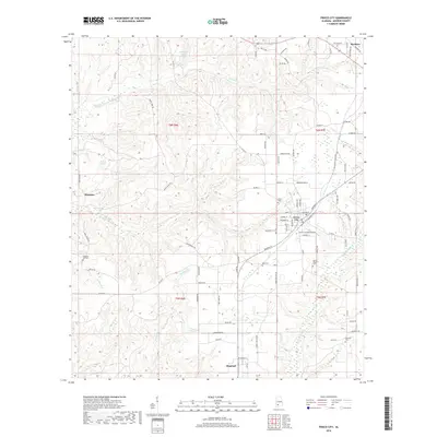
2018 Map of Frisco City
USGS Topo · Published 2018About this map
Frisco City serves as the central hub of this Monroe County landscape, where the local road network converges at the town's core near the local School. The area is characterized by a high density of ancestral sites, including the Shiloh Cem, Baas Cem, and Mount Pisgah Cem, which are tucked away along country routes like Bowden St and Hendrix St. Outside the town center, the terrain is defined by a network of creeks and ponds, with Randons Cr and Bear Cr winding through the countryside towards larger water bodies like Boroughs Pond and Moores Pond. This 2018 survey reveals a landscape of enduring rural settlements, from Mexboro in the northeast to Megargel and Manistee in the southwest, showing how modern land divisions in t6n r7e and surrounding townships have preserved the footprints of these established Alabama communities.
Find a feature on this map
92 named features on this map. Tap any name to fly to it.
Don’t see what you’re looking for? This feature index may not catch every label — zoom into the map to look around manually.
Map Details
Editions of this 2018 Frisco City Map
This is the sole edition of this map. No revisions or reprints were ever made.
Other maps of this area

1953 · Andalusia
USGS Topo · 1:250,000

1957 · Andalusia
USGS Topo · 1:250,000

1972 · Monroeville
USGS Topo · 1:24,000

1972 · Frisco City
USGS Topo · 1:24,000

1972 · Frisco City SE
USGS Topo · 1:24,000

1972 · Uriah East
USGS Topo · 1:24,000

1972 · Excel
USGS Topo · 1:24,000

1972 · Mexia
USGS Topo · 1:24,000

1972 · Uriah West
USGS Topo · 1:24,000

1972 · Flynns Lake
USGS Topo · 1:24,000