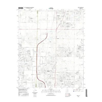
2016 Map of Frisco
USGS Topo · Published 2016About this map
The rapid suburban transformation of the North Texas corridor is evident across the Denton Co Collin Co boundary line. In the southern portion of the sheet, the city of Frisco shows a dense network of residential developments and academic infrastructure, including the Collin Coll Preston Ridge Campus. To the north, the town of Prosper and the settlement of Rockhill maintain a slightly more open character, though they are increasingly connected by a sophisticated grid of roads like Preston Rd and W University Dr.
Find a feature on this map
279 named features on this map. Tap any name to fly to it.
Don’t see what you’re looking for? This feature index may not catch every label — zoom into the map to look around manually.
Map Details
Editions of this 2016 Frisco Map
This is the sole edition of this map. No revisions or reprints were ever made.
Other maps of this area

1925 · Mc Kinney 3-c
USGS Topo · 1:48,000

1929 · Frisco
USGS Topo · 1:62,500

1929 · McKinney
USGS Topo · 1:62,500

1954 · Sherman
USGS Topo · 1:250,000

1958 · Sherman
USGS Topo · 1:250,000

1960 · Frisco
USGS Topo · 1:24,000

1960 · Celina
USGS Topo · 1:24,000

1960 · Plano
USGS Topo · 1:24,000

1960 · Aubrey
USGS Topo · 1:24,000
1960 · Lewisville East
USGS Topo · 1:24,000