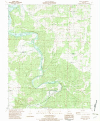
1982 Map of Fristoe
USGS Topo · Published 1982About this map
The Pomme de Terre River meanders through this landscape, creating the dramatic Alexander Bend and carving into the Buzzard Cave Bluff. The map documents a pivotal transition for the valley, showing the Harry S Truman Reservoir at its normal pool elevation, which significantly altered the local topography. This change is contrasted by the preservation of a State Wildlife Management Area and the rugged, hollow-cut terrain defined by Mining Hollow and Sloan Hollow.
Find a feature on this map
30 named features on this map. Tap any name to fly to it.
Don’t see what you’re looking for? This feature index may not catch every label — zoom into the map to look around manually.
Map Details
Editions of this 1982 Fristoe Map
This is the sole edition of this map. No revisions or reprints were ever made.
Other maps of this area

1884 · Bolivar
USGS Topo · 1:125,000

1887 · Warsaw
USGS Topo · 1:125,000

1892 · Bolivar
USGS Topo · 1:125,000

1894 · Warsaw
USGS Topo · 1:125,000

1935 · Edwards
USGS Topo · 1:24,000

1935 · Dell
USGS Topo · 1:24,000

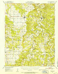
1945 · Fristoe
USGS Topo · 1:62,500

1947 · Jefferson City
USGS Topo · 1:250,000
1951 · Hermitage
USGS Topo · 1:62,500

1954 · Jefferson City
USGS Topo · 1:250,000