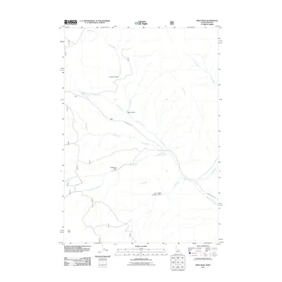
2011 Map of Fritz Peak
USGS Topo · Published 2011About this map
Fritz Peak serves as a central landmark in this high-elevation landscape along the Montana-Idaho border during the early 21st century. The map records the intersection of geography and early westward expansion, notably preserving the path of the Emigrant Trail as it crosses the southwestern portion of the quadrangle. This historic route is situated near the headwaters of South Fork Fritz Creek and North Fork Fritz Creek. The drainage patterns are complex, with waters flowing through Black Canyon and Limestone Gulch via Warm Creek, while the southeastern corner is defined by Medicine Lodge Creek. Modern access is represented by Bannack Pass Rd and Medicine Lodge Rd, tracing the same corridors that have connected these mountain passes for generations.
Find a feature on this map
18 named features on this map. Tap any name to fly to it.
Don’t see what you’re looking for? This feature index may not catch every label — zoom into the map to look around manually.
Map Details
Editions of this 2011 Fritz Peak Map
This is the sole edition of this map. No revisions or reprints were ever made.
Other maps of this area

1955 · Dubois
USGS Topo · 1:250,000

1957 · Scott Peak
USGS Topo · 1:62,500

1957 · Edie Ranch
USGS Topo · 1:62,500

1958 · Dubois
USGS Topo · 1:250,000

1965 · Caboose Canyon
USGS Topo · 1:24,000

1965 · Gallagher Gulch
USGS Topo · 1:24,000

1965 · Lima Peaks
USGS Topo · 1:24,000

1983 · Dubois
USGS Topo · 1:100,000
1987 · Deadman Lake
USGS Topo · 1:24,000
1987 · Fritz Peak
USGS Topo · 1:24,000