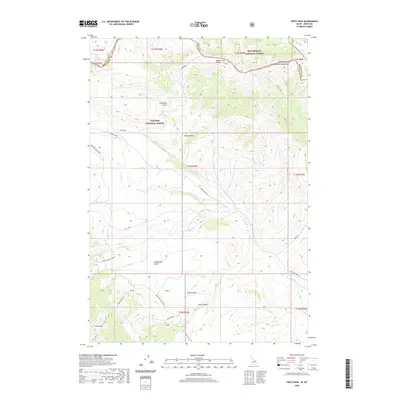
2020 Map of Fritz Peak
USGS Topo · Published 2020About this map
The Beaverhead Mountains form a dramatic natural boundary in this high-country survey, where the Continental Divide separates the Beaverhead National Forest in Montana from the Targhee National Forest in Idaho. This landscape is defined by the high crest of the divide, traced by the Continental Divide National Scenic Trail, and historical transit routes like Bannack Pass. The rugged terrain is etched with deep drainage patterns, including Black Canyon and the numerous branches of Fritz Creek, which flow toward the Medicine Lodge Bench. The presence of Emigrant Trail Rd and Bannack Pass Rd suggests the enduring importance of these mountain gaps for travelers and local ranching. Near the southern edge, Fritz Peak stands as a prominent landmark amidst a series of named gulches like Poison Gulch and Buckboard Gulch.
Find a feature on this map
46 named features on this map. Tap any name to fly to it.
Don’t see what you’re looking for? This feature index may not catch every label — zoom into the map to look around manually.
Map Details
Editions of this 2020 Fritz Peak Map
This is the sole edition of this map. No revisions or reprints were ever made.
Other maps of this area

1955 · Dubois
USGS Topo · 1:250,000

1957 · Scott Peak
USGS Topo · 1:62,500

1957 · Edie Ranch
USGS Topo · 1:62,500

1958 · Dubois
USGS Topo · 1:250,000

1965 · Caboose Canyon
USGS Topo · 1:24,000

1965 · Gallagher Gulch
USGS Topo · 1:24,000

1965 · Lima Peaks
USGS Topo · 1:24,000

1983 · Dubois
USGS Topo · 1:100,000
1987 · Deadman Lake
USGS Topo · 1:24,000
1987 · Fritz Peak
USGS Topo · 1:24,000