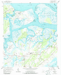
1956 Map of Frogmore
USGS Topo · Published 1987About this map
St Helena Island and its surrounding archipelago define this mid-century coastal landscape, dominated by a complex network of waterways including the Coosaw River and Morgan River. The map provides significant genealogical and social detail, highlighting the presence of Penn Community Services and the historic Brick Ch near the settlement of Frogmore. This area serves as a focal point for the island's community life, supported by numerous local institutions such as St Helena Sch and Ebenezer Ch.
Find a feature on this map
73 named features on this map. Tap any name to fly to it.
Don’t see what you’re looking for? This feature index may not catch every label — zoom into the map to look around manually.
Map Details
Editions of this 1956 Frogmore Map
3 editions found
Other maps of this area

1918 · Green Pond
USGS Topo · 1:62,500

1919 · Edisto Island
USGS Topo · 1:62,500

1920 · St. Helena Sound
USGS Topo · 1:62,500

1943 · Edisto Island
USGS Topo · 1:62,500

1943 · Green Pond
USGS Topo · 1:62,500

1944 · Fort Fremont
USGS Topo · 1:62,500

1947 · Savannah
USGS Topo · 1:250,000

1948 · St. Helena Sound
USGS Topo · 1:62,500

1948 · Savannah
USGS Topo · 1:250,000

1956 · Frogmore
USGS Topo · 1:24,000