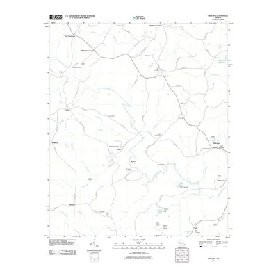
2011 Map of Frolona
USGS Topo · Published 2011About this map
Hillabahatchee Creek and its many tributaries, including Crews Creek and Copeland Creek, define the rural landscape of this corner of Georgia. The area is characterized by several historic focal points at road intersections, most notably Barkers Crossroads, Yates Crossroads, and Mahailey Crossroads. These junctions connect the scattered settlements of Simpson, Hyatt, and Ridley. For genealogists and local historians, the sheet is particularly dense with burial sites such as Lancaster Cemetery, New Springs Cemetery, and the Ridley-Davis Cemetery. High ground is marked by Backbone Ridge and Stone Mill Mountain, while the southern reaches feature the Meadow Lark Airport and Flat Rock Campground. The distribution of these family-named cemeteries and crossroads suggests a long-standing pattern of dispersed agricultural settlement tied to the undulating terrain and the creek networks that drain into Cedar Creek and Little Creek.
Find a feature on this map
90 named features on this map. Tap any name to fly to it.
Don’t see what you’re looking for? This feature index may not catch every label — zoom into the map to look around manually.
Map Details
Editions of this 2011 Frolona Map
This is the sole edition of this map. No revisions or reprints were ever made.
Other maps of this area

1899 · Wedowee
USGS Topo · 1:125,000

1902 · Wedowee
USGS Topo · 1:125,000

1953 · Atlanta
USGS Topo · 1:250,000

1957 · Atlanta
USGS Topo · 1:250,000

1958 · Atlanta
USGS Topo · 1:250,000

1964 · Glenn
USGS Topo · 1:24,000

1964 · Hillcrest
USGS Topo · 1:24,000

1964 · Roopville
USGS Topo · 1:24,000
1964 · Franklin
USGS Topo · 1:24,000
1964 · Lowell
USGS Topo · 1:24,000