
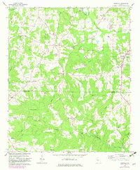
1964 Map of Roopville
USGS Topo · Published 1966About this map
Roopville sits at the eastern edge of this mid-1960s landscape, serving as a focal point for a rural Georgia region defined by its dense network of small communities and family-named landmarks. The terrain is divided by the Carroll Co and Heard Co line, which cuts across a landscape of creeks and church-centered settlements. Communities like Tyus, Ephesus, and Roosterville are connected by a web of unimproved dirt and light-duty roads that navigate the many branches of the Little Tallapoosa River and Centralhatchee Creek.
Find a feature on this map
49 named features on this map. Tap any name to fly to it.
Don’t see what you’re looking for? This feature index may not catch every label — zoom into the map to look around manually.
Map Details
Editions of this 1964 Roopville Map
2 editions found
Other maps of this area

1889 · Tallapoosa
USGS Topo · 1:125,000

1892 · Tallapoosa
USGS Topo · 1:125,000

1897 · Tallapoosa
USGS Topo · 1:125,000

1899 · Wedowee
USGS Topo · 1:125,000

1902 · Wedowee
USGS Topo · 1:125,000

1953 · Atlanta
USGS Topo · 1:250,000

1957 · Atlanta
USGS Topo · 1:250,000

1958 · Atlanta
USGS Topo · 1:250,000

1958 · Carrollton
USGS Topo · 1:62,500
1964 · Franklin
USGS Topo · 1:24,000