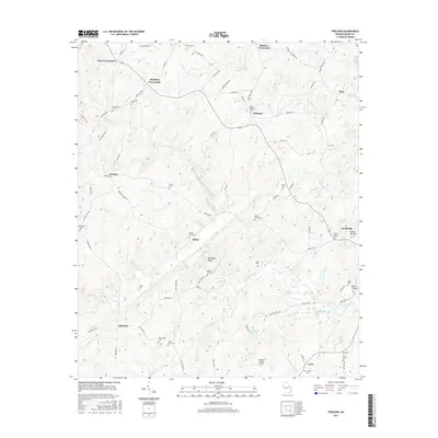
2017 Map of Frolona
USGS Topo · Published 2017About this map
Hillabahatchee Cr winds through the heart of this landscape, framing a series of crossroads communities such as Yates Crossroads, Mahailey Crossroads, and Barkers Crossroads. The topography is defined by prominent elevations like Backbone Ridge and Stone Mill Mtn, which overlook a network of rural routes including Frolona Rd and Mayhayley Rd. This area of Heard County is notable for its high density of family and community burial grounds, with sites like Macedonia Cem, Lancaster Cem, and Ridley-Davis Cem scattered across the countryside. Small-scale aviation and industry are represented by the Answered Prayer Airport and the bridge crossing at Watkins Bridge, while localized water features like Notnomis Acres Lake and Allens Lake dot the drainages of Cedar Cr and Little Cr.
Find a feature on this map
88 named features on this map. Tap any name to fly to it.
Don’t see what you’re looking for? This feature index may not catch every label — zoom into the map to look around manually.
Map Details
Editions of this 2017 Frolona Map
This is the sole edition of this map. No revisions or reprints were ever made.
Other maps of this area

1899 · Wedowee
USGS Topo · 1:125,000

1902 · Wedowee
USGS Topo · 1:125,000

1953 · Atlanta
USGS Topo · 1:250,000

1957 · Atlanta
USGS Topo · 1:250,000

1958 · Atlanta
USGS Topo · 1:250,000

1964 · Glenn
USGS Topo · 1:24,000

1964 · Hillcrest
USGS Topo · 1:24,000

1964 · Roopville
USGS Topo · 1:24,000
1964 · Franklin
USGS Topo · 1:24,000
1964 · Lowell
USGS Topo · 1:24,000