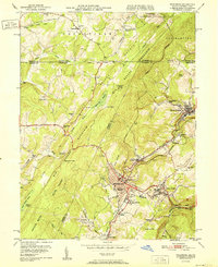
1951 Map of Frostburg
USGS Topo · Published 1951About this map
Frostburg and its surrounding coal-country settlements are captured here in the post-war era, illustrating a landscape defined by the intersection of early American transit and heavy industry. The historic National Pike and National Highway traverse the terrain near the Mason and Dixon Line, which marks the northern boundary of this survey. The industrial legacy of the region is evident in the dense network of the Cumberland and Pennsylvania railroad and the Western Maryland tracks, which served numerous mining communities like Eckhart Mines, Midlothian, and Grahamtown.
Find a feature on this map
73 named features on this map. Tap any name to fly to it.
Don’t see what you’re looking for? This feature index may not catch every label — zoom into the map to look around manually.
Map Details
Editions of this 1951 Frostburg Map
2 editions found
Other maps of this area

1898 · Frostburg
USGS Topo · 1:62,500

1899 · Grantsville
USGS Topo · 1:62,500

1901 · Frostburg
USGS Topo · 1:62,500

1904 · Grantsville
USGS Topo · 1:62,500

1908 · Frostburg
USGS Topo · 1:62,500

1921 · Meyersdale
USGS Topo · 1:62,500

1923 · Berlin
USGS Topo · 1:48,000

1929 · Berlin
USGS Topo · 1:62,500

1939 · Meyersdale
USGS Topo · 1:62,500

1944 · Berlin
USGS Topo · 1:62,500