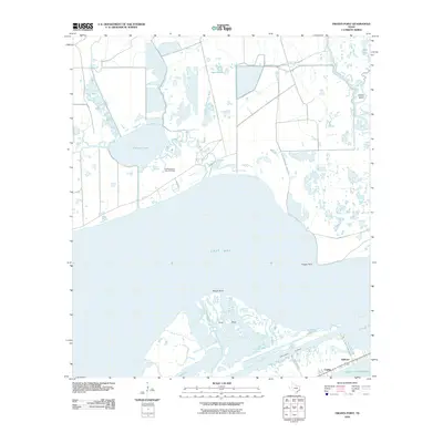
2010 Map of Frozen Point
USGS Topo · Published 2010About this map
East Bay dominates this coastal landscape, serving as the central divide between the marshy mainland and the thin barrier peninsula of Galveston County. The map details a complex hydrologic network of inlets and lagoons, including Robinson Lake and the Open Lakes, which are connected by a web of channels such as Cane Bayou and Oyster Bayou. On the southern edge, the small settlements of Rollover and Caplen sit precariously between the Intracoastal Waterway and the open Gulf of Mexico. The presence of the East Robinson Lake Gas Field indicates the industrial utility of these wetlands, while named landforms like Frozen Point, Marsh Point, and Long Point define the shifting shoreline. This environment reflects the interplay of maritime navigation and energy extraction along the Texas coast just before the second decade of the 21st century.
Find a feature on this map
16 named features on this map. Tap any name to fly to it.
Don’t see what you’re looking for? This feature index may not catch every label — zoom into the map to look around manually.
Map Details
Editions of this 2010 Frozen Point Map
This is the sole edition of this map. No revisions or reprints were ever made.
Other maps of this area

1931 · Flake
USGS Topo · 1:24,000

1931 · High Island
USGS Topo · 1:24,000

1931 · Frozen Point
USGS Topo · 1:24,000

1933 · Frozen Point
USGS Topo · 1:31,680

1933 · Caplen
USGS Topo · 1:31,680

1933 · Whites Lake
USGS Topo · 1:31,680

1933 · Flake
USGS Topo · 1:31,680

1943 · High Island
USGS Topo · 1:31,680
1943 · Flake
USGS Topo · 1:25,000

1943 · Frozen Point
USGS Topo · 1:24,000